

Con la Temporada de Huracanes EnZIHma
by ZihuaRob 
 , Zihuatanejo, México, Wednesday, April 24, 2024, 21:46 (927 days ago)
Remember that puff of wind from the south I said would change everything? Well, it puffed this Wednesday, and our weather has already changed abruptly. Say adiós to cool breezes. The breeze this Wednesday evening was warm, not cool at all. Next on the agenda will be increasing heat and humidity and decreasing breezes. We also usually see an increase in smokiness in this transition period to the rainy season aka HURRICANE SEASON, which begins officially in 3 weeks. Hang on to your britches 'cause this ride's just getting started!
Fires are currently so bad in Acapulco and Chilpancingo that they are closing their schools due to the poor air quality. Let's keep our fingers crossed we don't see such poor air quality here.
There are hardly any tourists around, but there is still a notable presence of visitantes extranjeros. Very unusual for this time of year. They appear to be mostly Canadians. I for one am glad to see them here, and I hope this is a trend that will continue. ¡Bienvenidos!
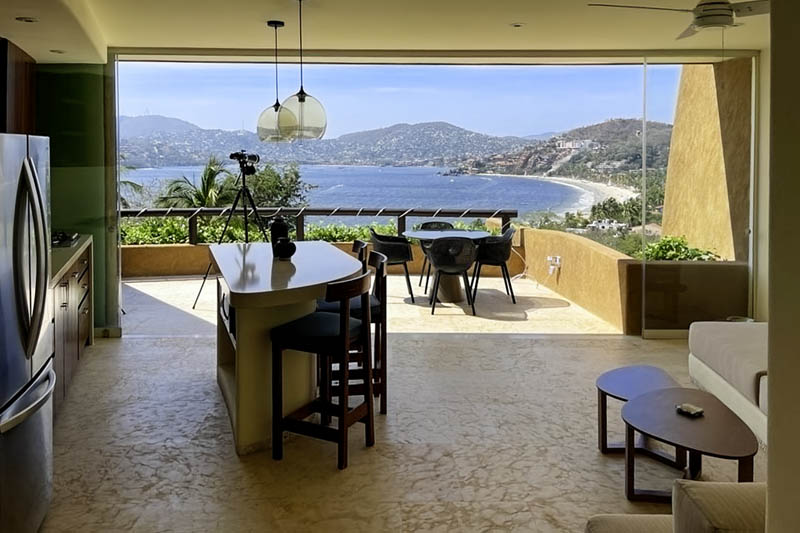 Located at the southern end of La Ropa Beach on the hillside about 100 meters from the beach, Armadillo 201 is a 2-bedroom luxury vacation rental condominium that offers a panoramic view of Zihuatanejo Bay from its roomy private balcony and terraces. The condo has air conditioning and comes with a private garage, and there is a pool with a sundeck on the property.
Zihuatanejo Vacation Rentals
¡Cuidemos nuestro patrimonio!
#MásSeguridadPúblicaMenosCemento
#NoQueremosBlueFlagEnLasPlayas
#PreservemosPlayaManzanillo
#DenunciaElEcocidioEnLaRopa
La Luna Rosa sale al mismo tiempo que hay un incendio en la cima del Cerro Darío Galeana al anochecer en Zihuatanejo.

Con la Temporada de Huracanes EnZIHma
by Padrino , Rosarito/Zihuatanejo, Thursday, April 25, 2024, 07:50 (927 days ago) @ ZihuaRob
Great photo, Rob! Bien hecho! Many Graces!
Better to be here than there
by Little Guy , Thursday, April 25, 2024, 14:13 (927 days ago) @ Padrino
From “Hurricane Tracker”…
We have already posted forecasts from AccuWeather and Colorado State University which both predicted an extremely active 2024 Atlantic Hurricane season with over 20 tropical cyclones. The two main factors causing forecasters to issue high numbers is because the Atlantic Ocean is already seeing water temperatures at July levels and a La Nina is forecasted over the eastern Pacific which leads to reduced wind shear in the Atlantic, allowing more storms to form. We already have the data to prove the Atlantic is very warm, but what is the status on La Niña? We will also discuss if we typically see more hurricanes in the Gulf during La Niña years.
Back in February, El Niño was in full force across the central and eastern Pacific near the equator with water temps running 2°C+ above average. Two months later (April 2024), sea surface temperatures have dramatically reversed and temps are near normal to slightly below average in the same region. This will have important ramifications on the upcoming hurricane season.
NOAA is forecasting over a 70% chance of La Niña by July/August/Sept (the heart of the hurricane season). No reason this will not verify given how quickly we are seeing the reversal of sea surface temperatures in the eastern Pacific. (NOAA Graphic).
During a La Niña, the Atlantic basin typically seas more frequent tropical cyclones and overall, they are stronger due to less wind shear. We may see less activity for the eastern Pacific basin this season.


